Hanford Site Risk Assessment
The largest environmental restoration effort in the nation, comprising 586 square miles (roughly half the size of Rhode Island), is being conducted at the Hanford Site in southeastern Washington State. The Hanford Site, located adjacent to the Columbia River, became a federal facility in 1943, when the U.S. Government took possession of the land to produce nuclear materials for national defense purposes. The Hanford Site’s production mission continued until the late 1980s, when the mission changed from producing nuclear materials to cleaning up the radioactive and hazardous wastes that had been generated during decades of operation.
Neptune partnered with two other small businesses—Environmental Quality Management and Environmental Assessment Services—to assist in planning, implementing, and documenting risk assessments at the site. We completed the River Corridor Baseline Risk Assessment, which includes upland, riparian, and near-shore resources along approximately 41 miles of the Columbia River shoreline. The ecological and human health risk assessment efforts evaluate risks from facility operations and reactors along and within the Columbia River as well as risk in areas in between the reactors and groundwater plumes. Neptune also worked with representatives of the Confederated Tribes of the Umatilla Indian Reservation (CTUIR) to implement the CTUIR Traditional Subsistence Lifeways exposure scenario for application in the River Corridor Baseline Risk Assessment.
The data evaluated in the risk assessment are depicted below and are accessed using GiSdT (Guided Interactive Statistical Decision Tools), developed by Neptune. GiSdT provides statistical guidance, performs analyses, and provides a mechanism for sharing data and analyses with stakeholders.
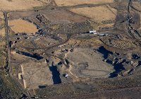
Hanford's 100 B/C Area undergoing remediation
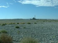
Backfilled and remediated waste site, B reactor in the background
The N reactor on the Columbia River shoreline


